
Geography Coloring Page and Printables: Fun Ways to Teach Map Learning, Continents, Countries, Oceans & Cultures
Hook / Opening statistic: More than 60% of educators report that visual and hands-on activities significantly increase retention in social studies — and geography coloring pages and printables are one of the easiest, most effective tools to use.
Whether you’re a homeschool parent looking to build engaging social studies lessons, a teacher planning a classroom unit, or a parent preparing for educational travel, this guide shows how to use geography coloring pages and printables to teach map learning, continents and countries, oceans, and world cultures. You’ll find proven strategies, ready-to-use activity ideas, printable templates, differentiation tips for multiple ages, and suggestions for classroom or home implementation. By the end, you’ll have a complete, actionable toolkit to make world geography memorable, meaningful, and fun.
Why Geography Coloring Pages and Printables Work for Learning
Geography printables and coloring pages combine visual learning, kinesthetic activity, and repetition — a powerful mix for memory and concept mastery. They support spatial reasoning, help students internalize map features (like scale, latitude, and longitude), and introduce cultural context in a tactile way.
- Visual encoding: Coloring helps students process and remember shapes, borders, and colors of countries and continents.
- Active learning: Cutting, labeling, and coloring engages motor skills and attention, boosting retention.
- Scaffolded complexity: Printables can be adjusted from simple continent maps to detailed country-level activities.
- Cross-curricular potential: Integrates social studies with art, language arts, and even math (scale, coordinates).
- Map symbols, compass rose, scale, legend
- Latitude and longitude basics; reading coordinates
- Types of maps: political, physical, climate, and resource maps
- Map skills: direction, distance, relative location
- Identifying the seven continents and major countries
- Country shapes and capitals practice
- Flag matching and country outline recognition
- Major oceans, seas, and important waterways
- Mountains, rivers, deserts, and biomes
- How physical geography shapes culture and settlement
- Cultural handouts, cuisine, festivals, and languages
- Virtual travel worksheets and travel journals for kids
- Comparative cultural studies: customs, clothing, and architecture
- Use for: Kindergarten–Grade 2
- Activity: Color each continent a different color; trace names of oceans
- Differentiation: Add continent facts for older students (size, population)
- Use for: Grades 1–4
- Activity: Color continent pieces, cut them out, and assemble on a blank world template
- Differentiation: Include country outlines for more advanced learners
- Use for: Grades 3–8
- Activity: Color the country, label the capital, and add one cultural fact
- Differentiation: Provide blank outlines for advanced students to label independently
- Use for: Grades K–6
- Activity: Color oceans and draw an animal native to each ocean
- Differentiation: Add a small research task on ocean conservation for older students
- Use for: All ages (tailor prompts by grade)
- Activity: Fill passport stamps, answer culture-oriented questions, record food tried, draw landmarks
- Differentiation: Include language phrases for older students to practice
- Use for: Grades 4–9
- Activity: Locate cities using given coordinates and plot routes between cities
- Differentiation: Introduce GPS coordinates and real-world navigation problems
- Warm-up (5 min): Show a large world map. Ask students to name what they see.
- Activity (20 min): Hand out continent coloring pages. Ask students to color each continent a different color and glue pieces on a blank map.
- Share (5–10 min): Students present one fact about their favorite continent.
- Assessment: Quick worksheet — match continent names to shapes.
- Warm-up (10 min): Quick quiz on continents and oceans.
- Activity (25–30 min): Students receive country outlines to color and match with capital cards hidden around the room (or digital scavenger hunt).
- Extension: Each student writes one cultural fact about their country.
- Assessment: Map quiz — place countries correctly on a blank map.
- Warm-up (10 min): Discuss why oceans are important for climate.
- Activity (30 min): Students label oceans and major currents on a printable map, then match marine species to their ocean habitat.
- Project (20–30 min): Small groups research an ocean conservation issue and create a one-page poster or printable brochure.
- Assessment: Rubric-based evaluation of posters and a short quiz on currents and oceans.
- For younger or lower-level learners: Use large-label maps, simplified tasks, and multisensory activities (sand, textured maps).
- For English language learners: Add bilingual labels, picture glossaries, and simple speaking prompts for culture pages.
- For gifted students: Offer extended research tasks, data analysis (population, GDP, climate graphs), or country comparison projects.
- For visually impaired learners: Provide tactile maps, raised-line diagrams, and audio descriptions accompanying printables.
- Observation checklists while students complete coloring and cut-and-paste tasks
- Exit tickets with 2–3 questions (e.g., name three continents; locate the Pacific Ocean)
- Quick peer quizzes using flashcards or printed matching cards
- Map labeling tests using blank printables
- Project rubrics for culture passports, travel journals, or posters
- Oral presentations to demonstrate location knowledge and cultural understanding
- Art: Create continent collages, design country flags, or paint biome landscapes from printables.
- Language Arts: Have students write travel journal entries from the perspective of a traveler visiting a country.
- Science: Use ocean printables for lessons on marine ecosystems and conservation.
- Math: Teach scale and distance with printable map grids and coordinate activities.
- Use country coloring pages to introduce landmarks and local languages.
- Fill out passports and travel journals with expectations and vocabulary.
- Simple map quizzes in transit help reinforce route awareness.
- Collect stamps, stickers, and photos to add to printable journals.
- Create a class travel bulletin board using student printables and photos.
- Assign reflection prompts: What surprised you? How did geography shape culture there?
- Canva: Easy-to-use templates for coloring pages and worksheets (use “world map coloring page” templates).
- Google Slides / PowerPoint: Simple layout tools to create printable pages and export as PDFs.
- National Geographic Education: Authoritative maps and classroom resources on continents, oceans, and cultures. (External link suggestion: https://www.nationalgeographic.org/education/)
- Library of Congress: Historical maps for primary-source integration. (External link suggestion: https://www.loc.gov/collections/)
- Local tourism boards & cultural institutes: Authentic materials and images for culture printables
- World map coloring page showing continent outlines and ocean labels
- Black-and-white printable continent puzzle pieces ready for coloring
- Country outline worksheet with space for capital and cultural facts
- Children filling in a travel passport printable during a homeschool lesson
- geography coloring page and printables
- homeschool social studies
- map learning
- continents and countries
- educational travel
- world map
- oceans
- cultures
- “Printable world map templates” — link to your site’s resource page with downloadable PDFs
- “Homeschool social studies curriculum” — link to your curriculum overview or lesson-plan index
- “Culture passport printables” — link to product or printable bundle page
- National Geographic Education — https://www.nationalgeographic.org/education/ (open in new window)
- UNESCO cultural heritage resources — https://en.unesco.org/ (open in new window)
- Library of Congress map collections — https://www.loc.gov/collections/ (open in new window)
- NOAA ocean resources for kids — https://oceanservice.noaa.gov/education/ (open in new window)
- Soft CTA (mid-article): “Download a free set of continent coloring pages and a travel journal printable — sign up for our newsletter.”
- Strong CTA (end of article): “Get the complete homeschool social studies printable bundle now — includes world map printables, country cards, ocean worksheets, and culture passports.”
- “Make map learning fun! Free geography coloring pages and printables for homeschool social studies.”
- “Travel with your students: printable passports, world maps, and culture journals.”

Core Topics You Can Teach with Printables
Geography printables cover a broad range of content. Below are the most effective themes and how they map to learning objectives:

Map Learning (Skills & Concepts)

Continents and Countries
Oceans and Physical Features
Cultures and Educational Travel
Ready-to-Use Printable Ideas & Templates
Below are printable types you can create or look for when curating resources. Each printable includes suggested learning objectives and differentiation options.
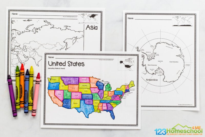
1. World Map Coloring Page (Basic)
Objective: Identify continents and oceans. Simple labeled outlines of continents with ocean names.
2. Continent Cut-and-Paste Puzzle
Objective: Improve spatial reasoning and continent recognition.
3. Country Outline and Capital Match
Objective: Recognize country shapes and memorize capitals.
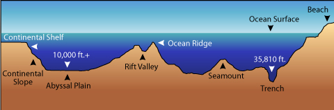
4. Ocean Facts & Marine Life Page
Objective: Teach ocean names, major currents, and marine biodiversity.
5. Culture Passport & Travel Journal Printables
Objective: Introduce cultural learning and reflective educational travel.
6. Map Skills Worksheets (Latitude/Longitude)
Objective: Learn coordinates and basic map reading.
Complete Lesson Plan Examples (with Printables)
Below are three scaffolded lesson plans you can implement immediately—each includes objectives, materials, step-by-step activities, and assessment ideas.
Lesson 1: Meet the Continents (30–45 minutes)
Grade: K–2
Materials: World map coloring page, crayons, scissors, world map poster or digital map
Lesson 2: Countries & Capitals Scavenger Hunt (45–60 minutes)
Grade: 3–6
Materials: Country outline printables, capital cards, world map, internet access for research
Lesson 3: Oceans, Currents & Climate (60–75 minutes)
Grade: 5–8
Materials: Ocean maps, printable marine-life cards, short article on ocean currents
Differentiation & Adaptations for Different Learners
Printables are highly adaptable. Use these tips to reach diverse learners, including special education, multilingual students, and gifted learners.
Assessment and Mastery: Measuring Geography Learning
Assess learning with both formative and summative strategies that fit printable-based activities.
Formative Assessments
Summative Assessments
Cross-Curricular Integration
Printables make it simple to integrate geography with other subjects. Use these cross-curricular ideas to deepen learning:
Educational Travel & Virtual Field Trips
Geography printables are perfect companions for real or virtual travel. Use them as pre-trip preparation, on-the-road activities, or post-trip reflection tools.
Pre-Trip
During Travel
Post-Trip
Printable Creation Tools & Recommended Resources
If you want to make your own printables or find high-quality ready-made resources, the following tools and sites are excellent starting points:
Image Alt Text Suggestions (for accessibility)
SEO & Internal/External Linking Recommendations
To help this article perform well in search and drive engagement, use the following linking strategy and on-page SEO tips:
Primary Keywords (use with 1–2% density)
Internal Link Suggestions (anchor text recommendations)
External Link Suggestions (authoritative sources)
Social Sharing & Calls to Action
Integrate CTAs naturally:
Social share copy suggestions:
FAQ — Quick Answers for Featured Snippets
What age is best for geography coloring pages and printables?
Printables can be tailored for all ages: simple continent coloring sheets for preschool–K, country outlines for elementary, and map-skill worksheets (latitude/longitude, scale) for middle and high school.
Can printables help with standardized testing in geography?
Yes. Printables build foundational map skills and factual knowledge that improve performance on geography-related test items, especially when combined with assessment rub

0 Comments